The Path Along the Rapallo Border

The Rapallo Border Theme Path has been designed to acquaint those who walk along all or part of it with the period between the 1st and 2nd World War and the effect the Rapallo border had on the towns and villages along its length. Armed with a copy of a leaflet giving details of the route and its history, I set off to explore!

The theme path begins at Žiri Museum – more about which, as well as the area itself, you can read in one of my blogs from earlier this year – https://adeleinslovenia.com/2017/04/17/discovering-the-most-ziri-things/

There is an information board opposite the museum. With your back to the board, head steeply – and I mean steeply! – uphill to Tabor and continue to follow the usual Slovenian hiking trail markers – a red circle with a white inner.

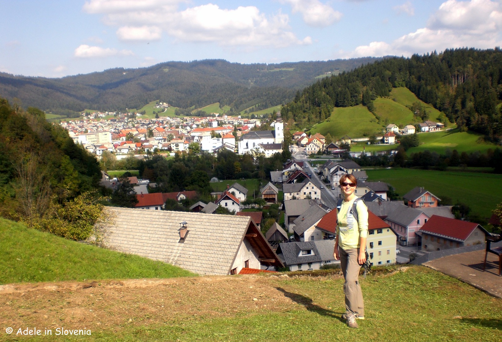
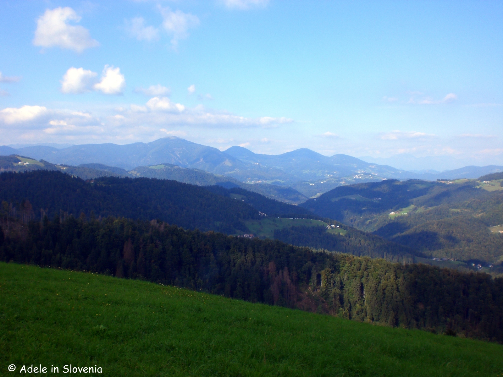
After just a few minutes you are already rewarded with a fantastic view over the town and valley.

The Rapallo Border was established as a result of the Treaty of Rapallo that was signed on 12th November 1920 in the Italian town of Rapallo. The treaty required a third of the territory of Slovenia to be handed over to Italy.

The effect on those living in the border areas was dramatic with neighbours, relatives and friends overnight becoming citizens of two separate kingdoms – the Kingdom of the Serbs, Croats and Slovenes (later the Kingdom of Yugoslavia), and the Kingdom of Italy.

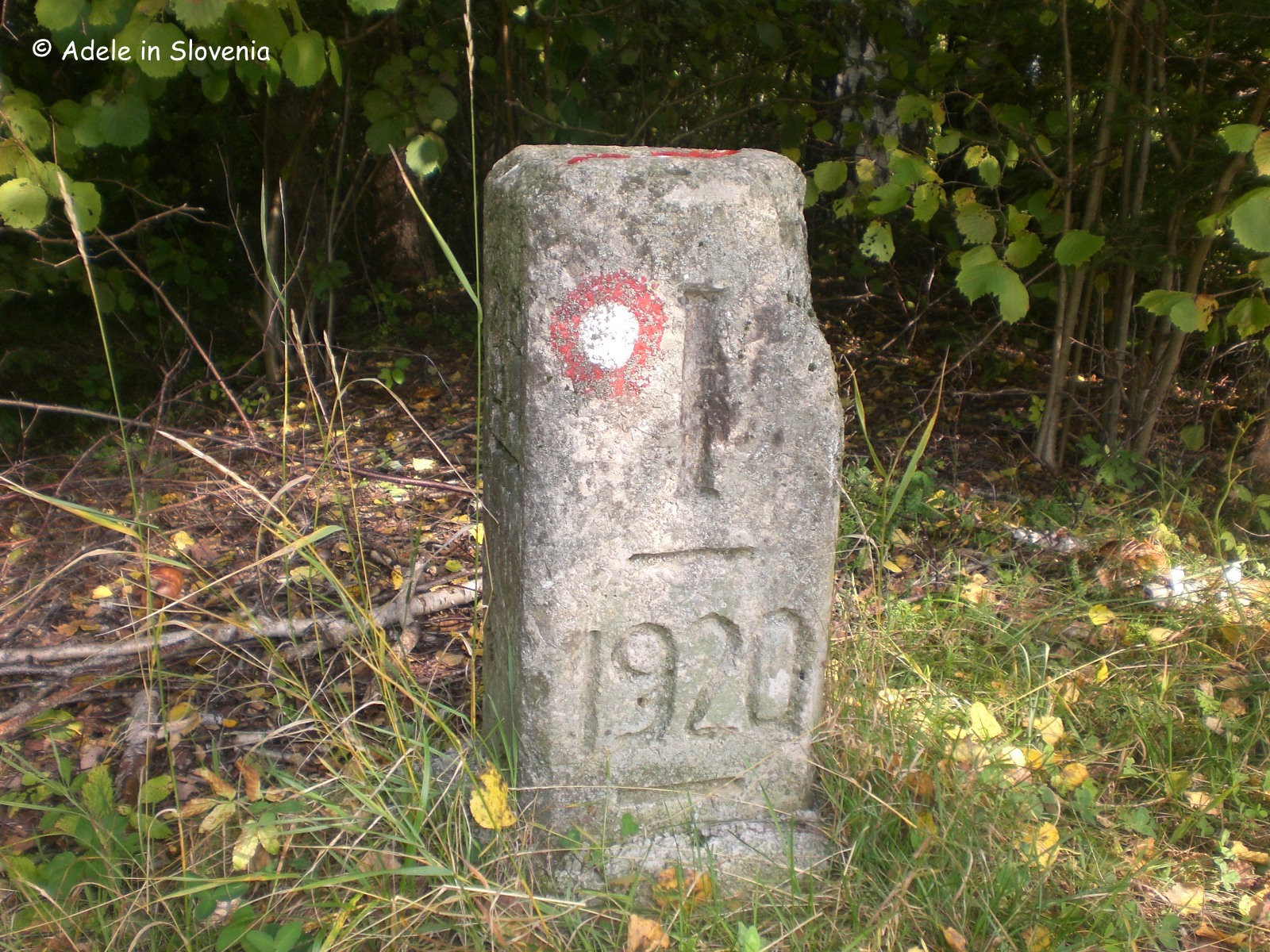
The entire border was 244km in length and was divided in 70 sections. At the start of each section there was a main boundary stone, with smaller boundary stones in between.

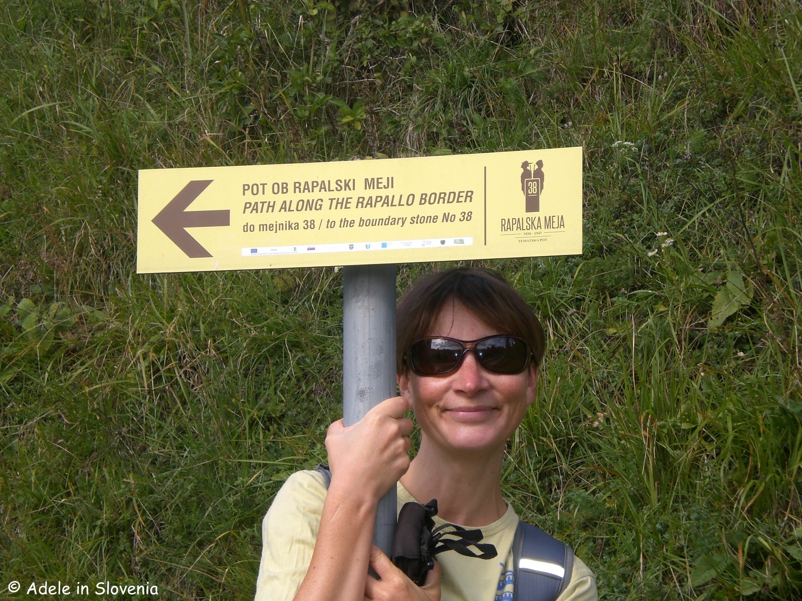
The Rapallo Border Theme Path covers the area of five main boundary stones numbered from 35 – 39.  The path is rather, or very, sparsely marked in places, so do keep your eyes peeled for the red and white circles (on trees, stones, buildings, behind you, in front of you, etc.) as well as the odd yellow theme path sign. Alternatively, you could contact Visit Škofja Loka and arrange to arrange a guide, thus eliminating any such worries, and getting the added benefit of the chance to find out more interesting facts and figures from a local expert.

You could choose to walk its entire length (46km, 9-10 hours), or for a shorter, easier version, take the circular path from Žiri to Mrzli vrh and back, which is 13km and takes approximately 4 hours, with optional extensions to additional boundary stones.

Shortly after leaving Tabor and emerging from the forest you are rewarded with another great view.

If you’ve got kids in tow, or in fact even if not, trying to spot the border stones can be treated as something of a treasure hunt! No. 39 was easy to spot…

..whereas as first I walked straight past no. 38 as it is somewhat concealed by a tree and undergrowth!

If you choose to continue to Mrzli vrh, at the village of Breznica the path descends a little on the road, before continuing upwards, at first on the road then again leading into the forest, towards the peak of Mrzli vrh and the Koča na Mrzlem vrhu mountain hut. The hut is open on Friday, Saturdays, Sundays and public holidays.

From here you could opt to return by the same route, or alternatively take the circular route via Ledenica to return to Žiri; the latter, however, means quite a few kilometres, though a pleasant walk, back through the valley to return to the museum.

The views that accompany you along the ridge of Mrzli vrh aren’t half bad either!

There is also an alternative start for the route which begins in Sovodenj and leads to Mrzli vrh (14km, cca.4 hours – one way), or you could walk a shorter circular route from Sovodenj to Nova Oselica and back (6km, cca. 2 hours).

For more information, see the Visit Škofja Loka website or visit the Škofja Loka Tourist Information Centre to pick up a leaflet – http://www.visitskofjaloka.si/en/experiences/theme-paths/rappalo-border

© Adele in Slovenia

Sunny Skiing, Stunning Views and Romance on Stari Vrh!

The Stari Vrh ski resort is located in the middle of the Selca and Poljane valleys, just a ten minute drive from Škofja Loka. It’s proximity to Ljubljana makes it a popular destination; in winter for skiing, snowboarding and other winter sports, and in summer for hiking and cycling.

15542209_1293678730652326_5805150049404543671_n

Stari Vrh offers 10kms of slopes (1km difficult, 5kms medium, 4kms easy), together with a snowboard park, night skiing, a toboggan run and a children’s snow playground.

dsc00301

Even for a non-skier like myself, it’s well worth donning your winter gear and taking the chairlift up to the top for the stunning panoramic views.

dsc00305

Once at the top, you will be blown away (hopefully not literally!) by the views over the Škofja Loka hills and further to the Kamnik-Savinja Alps.

dsc00312

The peak of Stari Vrh is at an altitude of 1217m.

dsc00313

At the top you can visit the cosy Stari Vrh Restaurant and Guest House, where you can enjoy a drink and/or snack, indulge in one of the Slovene specialities – all the while gazing at the stunning views – or stay overnight in one of the inn’s comfortable rooms and warm up in the sauna!

15940753_1190311254389828_459947133629103977_n

And since February is the month of romance, you might be interested to know that one of the ski pistes at Stari Vrh is named Valentine’s piste, after the nearby St. Valentines church in Jarčje Brdo. Additionally, the very scenic Valentine’s Path (Valentinova pot) begins at the lower station of the Stari Vrh chairlift. Note, however, that you will need to wait until at least spring before setting out to walk this path, as it runs on part of the ski piste, so can’t be walked when the ski centre is open.

The circular path is marked with green circles with a yellow inner and runs along old cart tracks and forest paths. It takes about 2 hours to complete, has a total height difference of 280 metres, and leads past the Žgajnar Tourist Farm, a 200-year old farmhouse in the hamlet of Zapreval, where in 1970 the Stari Vrh Tourist Association was founded. During winter there is a marked detour to reach Zapreval, since the ski pistes run almost literally past the front door, hence making it an excellent base for those on multi-day trips.

zgajnar

Today the tourist farm offers accommodation and delicious home-produced and home-cooked food year-round. You can read more about the tourist farm here – http://zgajnar.starivrh.si/presentation/Presentation.html

The path begins at the lower station of the chairlift at the Stari vrh ski resort and continues beside the Valentine ski piste to reach the exact boundary of the municipalities of Gorenja vas-Poljane and Škofja Loka, before rising up to the Stari vrh Restaurant and Guest House. It continues through the village of Mlaka past the Jejlar homestead (Jejlarjeva domačija), the famous house where the film Cvetje v jeseni (Blossoms in Autumn) was filmed. On reaching the village of Jarčje Brdo you will catch sight of the imposing St. Valentine’s parish church and return to the start of the walk.

Photo: TD Stari Vrh

Photo: TD Stari Vrh

Every year on 31st October there is an organised hike on Valentine’s Path, arranged by the Stari Vrh Tourist Association, beginning at 9am from the car park of the lower station of the 6-person chairlift at the Stari vrh ski resort.

The Association also arranges other events, including the popular Charcoal Makers Day, which has been held annually on the first Sunday in August since 1972.

251

Photo: TD Stari Vrh

Having seen how beautiful Stari Vrh is in winter, and the numerous opportunities the area offers for hiking and cycling in summer, I now can’t wait to go back and explore more of the area on foot or by bike. And when I do, you will be sure to read about it here!

wp_20161112_170

You can find out more about all the above on the Visit Skofja Loka website here – http://www.visitskofjaloka.si/en/about-us/tourism-board-skofja-loka

© Adele in Slovenia